IEM Cool Webcam Lapses
The IEM collects and archives still images from many webcams. We produce lapses of these still images each day. Sometimes these lapses capture something interesting, so they are shared on YouTube for all to easily see. This page highlights some of these lapses.
Most Recent Web Camera Videos
Recent videos are loaded from the public YouTube channel feed.
6 May 2007: Gravity Wave
Just a wonderful lapse of a gravity wave associated with an intense convective line early on 6 May 2007. This lapse is from the Tama webcamera and you can see the distinct wave action and the motion of the clouds within the wave.
4 MB MPEG12 March 2007: Iowa Blizzard
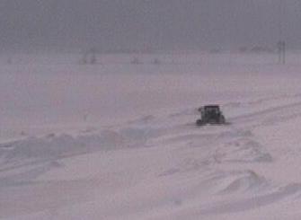
Winter brought everything it could muster during the last week of February and into March of 2007. Two ice and snow storms brought Iowa to halt by shuting down interstates from blowing snow with dangerous whiteout conditions. The webcamera at the ISU Agronomy Farm caught a great lapses of the blowing snow that was common after the storm.
- Attacking the drifts with a backhoe: View 640x480 MPG (1 MB)
- Drifts filling back in: View 640x480 MPG (1 MB)
- Finally, the sun setting: View 640x480 MPG (1 MB)
17 Jul 2006: Tama Tornado

A very short lapse from the Tama webcamera of a funnel cloud and possible tornado to the north of the webcamera. The tornado appears to touchdown for less than 30 seconds and quickly return to the cloud. The National Weather Service didn't receive any other confirmation of a tornado. It is certainly not clear if this was an actual tornado.
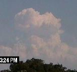
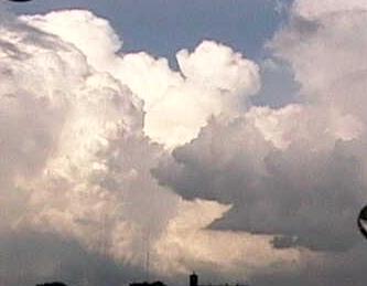
View 640x480 MPG (1 MB)6 Jun 2006: Explosive Convection
What a tremendous day for webcamera lapses of cumulus convection. This day saw a slow moving cold front provide just enough surface convergence to realize a modest amount of convective energy available in the atmosphere. The clear skies and dry air behind the front allowed from some great lapses.


22 Mar 2006: Radiation 101

After an early spring snow storm, the skies cleared nicely the next day allowing full sunshine to hit these two evergreen trees near the Ames webcam. What happened during the day and shown in this lapse can be found in the radiation 101 book. The green tree absorbs incoming short wave radiation from the sun and then emitts it back to the snow surface as long wave radiation. The snow reflects the short wave and absorbs the long wave thus melting the snow around the tree near the long wave radiation source (the trees).
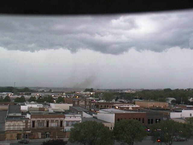
12 Nov 2005: Ames tornado
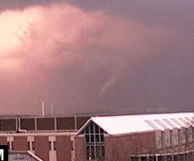
The second tornado caught by a web camera on this day. This tornado briefly touched down in NW Ames and badly damaged a few houses. It was the second tornado to hit the city of Ames in 2005.
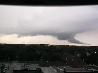
12 Nov 2005: Woodward tornado
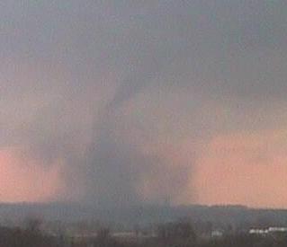
Just a great time lapse from the Madrid webcamera looking SW toward the city of Woodward. This storm produced extensive damage there, but the dissipation of the tornado shown in this lapse happened just as the tornado approached the city. It could have been much worse.
24 Jul 2005: Tama Cloud Burp

Nice little lapse of a quick updraft looking northeast from Tama around 7 PM. If you watch the lapse, you will see a little bit of ice get thrown out of the top of the cloud. It is kind of neat to see. 14 minutes of time elapse during this lapse.
12 Jun 2005: Creston Convection
Caught a neat lapse of growing convection looking east from Creston during the late afternoon. These storms were in an environment of about 2000 J/kg of CAPE and not much shear. They did not produce any significant hail or wind.
6 Jun 2005: Newton Convection

Caught this thunderstorm looking north from Newton. No severe weather was reported with this cell, but it made for a pretty lapse. You can see how this cell was not able to sustain an updraft. This lapse contains 900 frames between 3:45 and 5:45 PM.
8 May 2005: Tornado or Not Tornado...
Was this storm a tornado or not? It is hard to tell. It certainly did not last long. The movie shows a rotating(?) dust column to the west of Carroll between 5:06 and 5:09 PM. The cloud base is at about 4,000 feet and RADAR returns at the time were not indicating much rotation. You can decide for yourself.
29 Oct 2004: Super Cell!
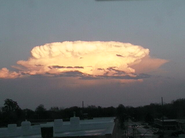
This is a fancy video at the anvil and overshooting top of a supercell east of the Winterset Camera. The day was characterized by very strong speed shear and good-enough convective available potential energy (CAPE). Storms away from the cold front were able to have decent organized structure.
27 Aug 2004: Humboldt Convection

This is a video of a supercell east of Humboldt. The convection in this storm is very vigorous and supported very large hail. This was one of the first cells to fire on a very active weather day in Iowa.
27 Aug 2004: Rockwell City Beaver Tail
This is a fantastic lapse of a beaver tail flowing into a vigorous thunderstorm. Storms on this day produced baseball-sized hail in numerous locations. This view is looking west.
11 July 2004: Carroll Convection Video #2

Another movie of bubbling convection from Carroll. This shot is looking northwest. This is not as nice as the #1 video, but it is still worth the download for you weather junkies.
4 July 2004: Carroll Convection Video #1

This is a fantastic movie of bubbling convection as captured by the webcamera in Carroll. This image is looking due east and near sunset.
11 June 2004: Tornado on Webster City Webcamera

This tornado was caught by the Webster City webcamera that is a part of KCCI's SchoolNet project. The movie is taken looking far south and a bit west.