contact us
disclaimer
apps
Iowa State University
Iowa Environmental Mesonet
contact us
disclaimer
apps
Iowa Atmospheric Observatory
Iowa Environmental Mesonet
CoCoRaHS
Daily Erosion Project
Weather.IM Project
Apps
Application Index
Automated Data Plotting
Climodat
Climodat Monitor
IEM Explorer
Hourly Precip
Interactive Radar
Pest Maps + Forecasting
Sortable Currents
Time Machine
Wind Roses
Areas
Ag Weather/Climate Info
Archive Mainpage
Climate Mainpage
Current Mainpage
Drought
GIS Mainpage
NWS Mainpage
Severe Weather Mainpage
Datasets
Daily Climatology
Daily Observations
Dataset Documentation
IEM Reanalysis
Model Output Statistics
NEXRAD Mosaic
PIREP - Pilot Reports
Roads Mainpage
RADAR & Satellite
Rainfall Data
Sounding Archive
Soil Moisture Satellite
Info
Info Mainpage
Daily Features
Links
News
Presentations
Referenced By
Station Data and Metadata
Quality Control
Variables
Networks
Network Tables
ASOS/AWOS Airports
CoCoRaHS - Citizen Science
DCP/HADS/SHEF - Hydrological
NWS COOP - Daily Climate
ISU Soil Moisture
NLAE Flux
RWIS - Roadway Weather
SCAN - NRCS Soil Climate
Other
US Climate Reference
NWS Data
NWS Mainpage
Local Storm Report App
IEM Cow (SBW Verification)
IEM Raccoon (SBW Powerpoints)
River Summary
Satellite Data
Search for Warnings
Special Weather Statement (SPS) Search
SPC Convective Outlook / MCD Search
SPC Watches
Text Archives Mainpage
Text Listing by WFO/Center/Product
Text by Product ID
VTEC Browser
Services
API Mainpage
CGI / Bulk Data
Gibson Ridge Placefiles
iembot
JSON Webservices
LDM
Max CSV
OGC Webservices
RadMap API
RADAR Services
Webcams
Webcam mainpage
Build your own lapses
Cool lapses
IEM Webcam Viewer
ISU Campus Webcams
Recent lapses
Still images
Station Data & Metadata
LA_ASOS
[IYA] Abbeville [2008-]
[0R3] Abbeville [2008-2011]
[ESF] Alexandria - Esler [1941-]
[AEX] ALEXANDRIA INTL/ENGLAND AFB [1943-]
[7R3] AMELIA/LAKE PALOURD [1978-2016]
[ATP] Atlantis [2010-]
[AUD] Audubon Park [2000-2016]
[BAD] BARKSDALE AFB [1937-]
[BQP] Bastrop [2006-]
[BTR] BATON ROUGE/RYAN [1932-]
[WBF] Block WR29 [2018-]
[BXA] Bogalusa [1998-]
[BVE] BOOTHVILLE [1965-2023]
[1B7] BOOTHVILLE/R L SUGGS HELIPORT [1999-2016]
[LNQ] Buras [2019-2023]
[CVW] Cameron [1981-2019]
[7R5] CAMERON HELIPORT [1982-2005]
[5R8] De Quincy [2012-]
[DRI] DE RIDDER/BEAUREGARD REGIONAL [1943-]
[EHC] East Cameron [2010-2018]
[EZP] East Cameron 321A [2020-]
[E12] East Cameron 345 [2002-2002]
[CMB] East Cameron 47 [2010-2012]
[EIR] Eugene Island 215 [2010-2021]
[3B6] EUGENE ISLAND 330 [2000-2009]
[POE] FORT POLK (ARMY) [1957-]
[9F2] FOURCHON (SAWRS) [1987-]
[BKB] Fullerton - Fort Polk [2005-]
[GAO] Galliano [1972-]
[2GL] GALLIANO HELIPRT [2004-2008]
[AGI] Garden Banks [2021-]
[SQE] GOMEX Ship Shoal 354 [2014-2017]
[REG] Gonzale [2014-]
[L38] Gonzales [2012-]
[3L4] Grand Chenier [1987-]
[AXO] GRAND ISLE (SAWRS) [1987-2016]
[ANR] Green Canyon [2024-]
[XCN] GREEN_CANYON_184 [1999-2006]
[XER] Green Canyon 19 [2024-]
[GRY] Green Canyon 338 [2010-]
[MKQ] Green Canyon 433 [2023-]
[TAH] Green Canyon 641 [2024-]
[HDC] HAMMOND MUNI AIRPORT [2001-]
[XIH] High Island 179A [2010-2020]
[H08] HIGH ISLAND 264C [1996-2013]
[HUM] HOUMA-TERREBONNE [1945-]
[IPN] Independence (GoM) [2009-2016]
[7R4] INTRACOASTAL CITY [1976-2015]
[3R7] Jennings [2012-]
[LFT] Lafayette [1937-]
[LCH] Lake Charles [1942-]
[CWF] Lake Charles - Chennault Intl [1918-]
[T41] La Porte [2019-]
[GBK] Magnolia (GoM) [2010-]
[3F3] Mansfield [2016-]
[MKV] Marksville
[MNE] Minden [2010-]
[CYD] MISS CANYAN 807 [2005-]
[MDJ] Mississippi Canyon [2010-2021]
[DSF] Mississippi Canyon 650 [2018-]
[GLX] Mississippi Canyon 724 [2022-]
[ETO] Mississippi Canyon 941 [2024-]
[MLU] MONROE REGIONAL [1912-]
[IER] NATTCHITOCHES REGIONAL AIRPORT [1999-]
[ARA] New Iberia - Acadiana [1961-]
[7N0] New Orleans Downtown [2012-2023]
[NEW] NEW ORLEANS/LAKEFRO [1942-]
[MSY] NEW ORLEANS/MOISANT [1932-]
[NBG] NEW ORLEANS NAS [1949-]
[HZR] New Roads [2012-]
[ACP] OAKDALE/ALLEN PARISH ARPT [2005-]
[H78] Offshort [2007-2020]
[4C0] Oil Platform [2003-2011]
[OPL] Opelousas [2013-]
[PTN] PATTERSON MEMORIAL [1984-]
[AQV] Peason Ridge - Ft Polk [2005-]
[QT8] PHI OIL PLATF [2005-2011]
[QT9] PHI OIL PLATF [2005-2011]
[XPY] Port Fourchon [2011-2020]
[APS] Reserve [2014-]
[RSN] Ruston [2000-]
[VBS] Sabine 13B [2010-2019]
[GHB] Salsa [2010-]
[P92] Salt Point [1985-]
[DNK] SELF FLS/JRTK_FT_POLK ASOS [2005-2013]
[GSM] SHIP SHOAL 207A [2000-2010]
[SPR] Ship Shoal (GoM) [2009-2020]
[DTN] SHREVEPORT DOWNTOWN [1981-]
[SHV] SHREVEPORT REGIONAL [1934-]
[ASD] SLIDELL [1998-]
[SCF] South Marsh 268 [2010-2021]
[7R8] SOUTH MARSH ISLAND [1984-2003]
[SRN] SOUTH MARSH ISLAND BLOCK 268A [1972-2010]
[MTK] South Pass 89E-B [2019-]
[STZ] South Timbalier [2011-2013]
[S58] SOUTH TIMBALIER [1987-2011]
[OYE] South Timbalier 52B [2024-]
[UXL] Sulphur [2006-]
[JSL] Unnamed Oil Rig [2025-]
[VNP] Vermillion 26 [2010-2013]
[VQT] Vermillion 331 [2011-2023]
[TVR] Vicksburg / Tallulah [1996-]
[0R4] Vidalia [2016-]
[VOA] Viosca Knoll [2011-]
[W60] W. CAMERON 560 [2000-2005]
[VKY] Zapata-Yorktowntlat [2011-2023]
or
select from map
Information
Last Ob
Photographs
Meteogram
Network Table
Neighbors
Monthly Summaries
Observation History
Wind Roses
Custom Wind Roses
Data Calendar
Satellite Cloud Product
Download
Terminal Aerodome Forecast
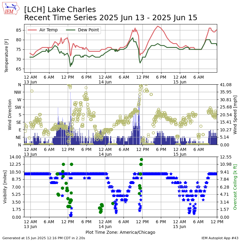
This page creates a simple plot of recent observations from this site.