contact us
disclaimer
apps
Iowa State University
Iowa Environmental Mesonet
contact us
disclaimer
apps
Iowa Atmospheric Observatory
Iowa Environmental Mesonet
CoCoRaHS
Daily Erosion Project
Weather.IM Project
Apps
Application Index
Automated Data Plotting
Climodat
Climodat Monitor
IEM Explorer
Hourly Precip
Interactive Radar
Pest Maps + Forecasting
Sortable Currents
Time Machine
Wind Roses
Areas
Ag Weather/Climate Info
Archive Mainpage
Climate Mainpage
Current Mainpage
Drought
GIS Mainpage
NWS Mainpage
Severe Weather Mainpage
Datasets
Daily Climatology
Daily Observations
Dataset Documentation
IEM Reanalysis
Model Output Statistics
NEXRAD Mosaic
PIREP - Pilot Reports
Roads Mainpage
RADAR & Satellite
Rainfall Data
Sounding Archive
Soil Moisture Satellite
Info
Info Mainpage
Daily Features
Links
News
Presentations
Referenced By
Station Data and Metadata
Quality Control
Variables
Networks
Network Tables
ASOS/AWOS Airports
CoCoRaHS - Citizen Science
DCP/HADS/SHEF - Hydrological
NWS COOP - Daily Climate
ISU Soil Moisture
NLAE Flux
RWIS - Roadway Weather
SCAN - NRCS Soil Climate
Other
US Climate Reference
NWS Data
NWS Mainpage
Local Storm Report App
IEM Cow (SBW Verification)
IEM Raccoon (SBW Powerpoints)
River Summary
Satellite Data
Search for Warnings
Special Weather Statement (SPS) Search
SPC Convective Outlook / MCD Search
SPC Watches
Text Archives Mainpage
Text Listing by WFO/Center/Product
Text by Product ID
VTEC Browser
Services
API Mainpage
CGI / Bulk Data
Gibson Ridge Placefiles
iembot
JSON Webservices
LDM
Max CSV
OGC Webservices
RadMap API
RADAR Services
Webcams
Webcam mainpage
Build your own lapses
Cool lapses
IEM Webcam Viewer
ISU Campus Webcams
Recent lapses
Still images
Station Data & Metadata
UT_RWIS
[UT11] 9000S/I15 NB [2002-2018]
[SND] Arrowhead Summit [2011-2015]
[UTASG] Aspen Grove [2010-2015]
[BAC] BACCUS/SR111 [2002-]
[UT8] BLUFFDALE [2002-2005]
[UT7] BLUFFDALE [2002-]
[BHCU1] Brian Head 2S [2007-]
[BUNUT] Bunnells [2007-2015]
[UTCDF] Cardiff - Big Cottonwood Canyon UT US UTAH DOT [2013-]
[CSC] Cascade Ridge [2003-2014]
[CEN] Centerville [2003-]
[UTCKH] Chaulk Hill [2009-]
[CCS] Clear Creek Summit I70 [2003-]
[DCC] Deer Creek Dam [2011-2015]
[UTDOG] Dog Valley [2005-2020]
[UTFMC] Foothill Dr at Mario Capecchi Dr UT US UTAH DOT [2019-]
[FRE] FREMONT JUNCTION [2003-]
[GHO] Ghost Rocks [2003-]
[UT23] I-15/2400 S Spaghetti [2002-]
[UT18] I15 400S SB [2002-2005]
[UT19] I15 400S SB (HOV/Deck) [2002-2005]
[UT20] I15 500S WB (Gateway) [2002-]
[UT17] I-15/600 N SALT LAKE CITY [2002-2005]
[UT21] I15 600S NB [2002-2014]
[UTBEV] I-15 at Beaver [2015-]
[UTDVC] I-15 at MP 139 Dog Valley Creek UT US UTAH DOT [2024-]
[UTBCN] I-15 at MP 140 Baker Canyon [2023-]
[UT144] I-15 at MP 144 [2023-]
[UTLMP] I-15 at MP 215 Lampson Canyon [2019-]
[UTRKY] I-15 at MP 241 Rocky Ridge [2019-]
[UTBRO] I-15 at MP 29 Browse [2021-]
[UTANT] I-15 at MP 333 Antelope Drive [2021-]
[UTFRW] I-15 at MP 350 Farr West [2018-]
[UTNBC] I-15 at MP 369 North Brigham Cit UT US UTAH DOT [2018-]
[UTACR] I-15 at MP 37 Ash Creek [2021-]
[UTPOR] I-15 at MP 398 Portage [2020-]
[UTHFT] I-15 at MP 54 Hamiltons Fort [2020-]
[UTCDC] I-15 at MP 57 Cedar City [2018-]
[UTNCC] I-15 at MP 62.5 North Cedar City UT US UTAH DOT [2020-]
[UTPRG] I-15 at Paragonah [2017-]
[UTPCH] I-15 at Pine Creek Hill [2016-]
[UTWCR] I-15 at Wildcat Ridge [2015-]
[UTBVR] I-15 @ Beaver Ridge [2011-]
[UTBRC] I-15 @ Beer Creek [2014-]
[UTBLK] I-15 @ Black Ridge [2005-]
[UT12] I15/I215 SB [2002-]
[UT13] I15/I215 SB Deck [2002-2005]
[UTCIR] I-15 @ MP 169 [2017-]
[UTORM] I-15 @ Orem [2013-]
[UT29] I-15 @ Plymouth [2005-]
[UTPRV] I-15 @ Provo [2013-]
[UTPVO] I-15 @ Provo Center St [2005-2010]
[UTSCI] I-15 @ Scipio Summit [2005-]
[UT26] I-15 @ Sevier River NB [2005-]
[UT27] I-15 @ Sevier River SB [2006-2008]
[UT28] I-15 @ Tremonton [2005-]
[UTWLD] I-15 @ Willard POE [2005-]
[UT14] I-215/280E MURRAY [2002-2007]
[UT215] I-215 at I-80 [2017-]
[UT2SR] I-215 at MP 13.5 Redwood Rd [2022-]
[UTTAY] I-215 at MP 16 Taylorsville [2020-]
[UTOLY] I-215 at Olympus Cove [2017-]
[UT15] I-215/JORDAN RIVER SALT LAKE CNTYUT US UTAH DOT [2002-2007]
[UTI70] I-70 at I-15 [2016-]
[UTHAD] I-70 at MP 226 Harley Dome [2023-]
[UTSCN] I-70 at MP 69 Salina Canyon [2023-]
[UTRCH] I-70 at Richfield [2017-]
[UTSLA] I-70 at Salina [2015-]
[UTSSU] I-70 at Salina Summit [2018-]
[UTCRE] I-70 @ Crescent Jct [2007-2011]
[UTFSH] I-70 @ Fish Creek [2013-]
[UT107] I-80 at MP 107 [2021-]
[UTSUG] I-80 at MP 125 Sugar House [2023-]
[UTMTA] I-80 at MP 132 Mt. Aire [2023-]
[UTECY] I-80 at MP 134 East Canyon [2023-]
[UTLAM] I-80 at MP 136 Lamb's Canyon [2019-]
[UTPCC] I-80 at MP 138 Parleys Creek Cro UT US UTAH DOT [2024-]
[UTPLB] I-80 at MP 139.5 Parleys Lane Br UT US UTAH DOT [2023-]
[UTJER] I-80 at MP 142 Jeremy Ranch [2023-]
[UTTOL] I-80 at MP 151 Tollgate Canyon [2020-]
[UTECO] I-80 at MP 172 Echo Canyon [2018-]
[UTTP2] I-80 at MP 2 Tripod [2016-]
[UTKNO] I-80 at MP 40 Knolls [2021-]
[UTWDL] I-80 at MP 68 West Delle [2018-]
[UTEDL] I-80 at MP 71 East Delle [2018-]
[UTTIM] I-80 at MP 79 Timpie [2018-]
[UTDOL] I-80 at MP 81 Dolomite [2018-]
[UTCOL] I-80 @ Coalville [2014-]
[UTGRS] I-80 @ Grassey [2005-]
[UT32] I-80 @ mp 1 [2009-]
[UT33] I-80 @ mp 29 [2009-]
[UT31] I-80 @ mp 78 [2009-]
[UT16] I-80/REDWOOD ROAD SALT LAKE CITY UT US UTAH DOT [2002-2008]
[UTSVC] I-80 @ Silver Ck Jct [2005-]
[UTWAN] I-80 @ Wanship [2014-]
[UTTAG] I-84 at MP 108 Taggarts [2021-]
[UTDVG] I-84 at MP 91 Devils Gate [2021-]
[UTPET] I-84 at MP 97 Peterson [2025-]
[UTDEV] I-84 @ Devils Slide [2011-]
[UTWTV] I-84 @ Whites Valley [2005-]
[UTICS] Indian Canyon Summit [2008-]
[UTPW3] James Peak [2013-2015]
[UTJPS] Johnsons Pass [2014-]
[KIJ] Kimball Junction I80 [2003-]
[KCWU1] King Canyon [2006-]
[KNC] KNUDSENS CORNER [2003-2008]
[UT9] LAKE POINT I-80 [2002-]
[UT10] LAKE POINT SR36 [2002-2006]
[UTLGP] Legacy Parkway [2008-]
[LGS] Logan Summit [2003-]
[SNM] Mid Mountain [2011-2015]
[UT5] MOUTH PARLEYS [2002-]
[UTNOD] North Ogden Divide [2024-]
[UTPSH] Parleys Canyon Maintenance Stati UT US UTAH DOT [2007-2009]
[UTQRY] Parleys Canyon @ Quarry [2008-]
[PSS] PARLEYS SUMMIT [2003-2004]
[UT4] PARLEYS SUMMIT [2002-2008]
[UT3] PARLEYS SUMMIT [2002-]
[UTPCR] Pioneer Crossing [2011-]
[UTALP] Point of the Mountain (I-15 Alpi UT US UTAH DOT [2006-]
[UTPRT] Portable RWIS [2008-2013]
[UTPR1] Portable RWIS 1 [2013-2019]
[UTPR2] Portable RWIS 2 [2010-]
[UTPR3] Portable RWIS 3 [2011-]
[UTPR4] Portable RWIS 4 [2011-]
[UTPR5] Portable RWIS 5 [2011-2024]
[UTPT1] Portable Traffic 1 [2011-2023]
[UTPT2] Portable Traffic 2 [2011-2023]
[UTPR0] Portable Tripod [2013-2014]
[UTPWD] Powder Mountain [2009-2015]
[PDM] Powder Mountain [2002-2004]
[UTPW2] Powder Mountain 2 [2012-2015]
[UTPLC] Powerhouse - Little Cottonwood C UT US UTAH DOT [2015-]
[PWR] POWER PLANT [2003-]
[UTPCY] Provo Canyon @ mp10 [2009-]
[UTTP3] Rainbow Road Tripod [2016-]
[RTB] Rattlesnake Bench [2003-]
[RDN] Red Narrows [2003-]
[HQ2] REGION 2 HEADQUARTERS [2002-2004]
[UTRIV] Riverdale Rd. [2013-]
[SWH] Sherwood Hills [2003-]
[SKY] Skyline [2003-]
[UTSLD] Soldier Summit [2006-]
[UTPSB] SR-10 at MP 54 Poison Spring Ben UT US UTAH DOT [2018-]
[UT112] SR-112 @ MP 6 Utah Avenue [2021-]
[UTELP] SR-121 at MP 31.5 East Lapoint [2024-]
[UTBLD] SR-12 @ Boulder Summit [2009-]
[UTMVP] SR-130 at MP 32 Minersville Pass UT US UTAH DOT [2023-]
[UTPRB] SR-131 at MP 0.5 Porter Rockwell UT US UTAH DOT [2023-]
[UTTP5] SR-143 at MP 13.5 Brian Head Tri UT US UTAH DOT [2019-]
[UT14S] SR-14 Summit [2016-]
[UTBMP] SR-150 at Bald Mountain Pass [2015-]
[UTPFL] SR-153 near Puffer Lake [2015-]
[UTB21] SR-154 at MP 21 2100 S [2022-]
[UTRVT] SR-154 at MP 7 Riverton [2023-]
[UTPOW] SR-158 at MP 11.5 Powder Mountai UT US UTAH DOT [2023-]
[UTMVY] SR-163 at MP 0.5 Monument Valley UT US UTAH DOT [2020-]
[UTS16] SR-16 @ MP1 [2008-]
[UTWDS] SR-177 at MP 14.5 Syracuse [2024-]
[UTWDK] SR-177 at MP 5 Kaysville [2024-]
[UTBTN] SR-190 at MP 16 Brighton [2024-]
[UTDUG] SR-196 at MP 2 Dugway [2022-]
[UT24] SR201 800W [2003-2007]
[UT22] SR201 800W EB/WB [2003-2012]
[UT201] SR-201 at I-80 [2016-]
[UT224] SR-224 at Meadows Drive [2017-]
[UTONM] SR-224 at MP 3 Ontario Mine [2022-]
[UT248] SR-248 [2008-]
[UTCOM] SR-248 at MP 1 Comstock Dr [2022-]
[UTWAY] SR-24 @ Wayne Summit [2013-]
[UTELL] SR-276 at MP 21.5 Mt. Ellsworth UT US UTAH DOT [2023-]
[UT30] SR-30 [2009-]
[UTLTS] SR-30 at MP 124 Laketown Summit UT US UTAH DOT [2020-]
[UTCUR] SR-30 @ Curlew [2009-]
[UTMRN] SR-32 at MP 16.5 Marion [2019-]
[UTWLF] SR-35 at Wolf Creek Summit [2014-]
[UTSTO] SR-36 at MP 49 Stockton Bar [2021-]
[UTTLE] SR-36 at MP 57 Tooele [2021-]
[UTBSU] SR-36 at MP 6 Boulter Summit [2023-]
[UTPVD] SR-39 at MP 14 Pineview Dam [2024-]
[UTHUN] SR-39 at MP 17.5 Huntsville [2023-]
[UTMON] SR-39 at MP 46 Monte Cristo [2020-]
[UT43W] SR-43 at MP 0.5 West Stateline [2020-]
[UTMOP] SR-44 at MP 9 Moose Pond [2020-]
[UTLSD] SR-46 at MP 12.5 La Sal Divide [2020-]
[UTIMS] SR-56 at MP 43 Iron Mountain Sum UT US UTAH DOT [2023-]
[UTBIG] SR-65 at Big Mountain Pass [2014-]
[UTLAK] SR-68 at MP 16 Mosida [2018-]
[UTHGP] SR-72 at Hogan Pass [2015-]
[UTSHR] SR-7 at MP 19.5 Sand Hollow [2022-]
[UTMV2] SR-85 at SR-201 [2021-]
[UTDWY] SR-85 @ Dannon Way [2013-]
[UTJUN] SR-85 @ Juniper [2012-]
[UTMTH] SR-87 at MP 16 Mountain Home [2024-]
[UTAFC] SR-92 at MP 12 American Fork Can UT US UTAH DOT [2021-]
[UTSAL] SR-95 @ Salvation Knoll [2009-]
[UTSTR] S-Turns - Big Cottonwood Canyon UT US UTAH DOT [2014-]
[UTTPD] Torpedo Hill - Big Cottonwood Ca UT US UTAH DOT [2014-]
[TPR] TRAPPERS LOOP ROAD [2003-]
[ELBUT] UDOT LCC Elberts [2008-2015]
[UTCHL] US-189 at Charleston [2017-]
[UTDCD] US-189 at Deer Creek Dam [2016-]
[UTLPC] US-189 at Lower Provo Canyon [2016-]
[UTFIM] US-191 at MP 104 Flat Iron [2023-]
[UTWPO] US-191 at MP 369 Windy Point [2020-]
[UTBAS] US-191 at MP 377 Bassett Spring UT US UTAH DOT [2020-]
[UTWIS] US-191 at MP 386 Willie Spring [2020-]
[UTMYT] US-40 at MP 105 Myton [2020-]
[UTASH] US-40 at MP 140 Asphalt Ridge [2020-]
[UTCOP] US-40 at MP 41 Co-Op Creek [2019-]
[UTFRT] US-40 at MP 66 Fruitland [2019-]
[UTSCB] US-40 at Silver Creek Bridge [2025-]
[UTDAN] US-40 @ Daniels Summit [2011-]
[UTHEB] US-40 Heber [2008-]
[UTMFS] US-40 Mayflower Summit [2008-]
[UTSTV] US-40 @ Starvation [2006-]
[UTMPO] US-491 at MP 2 Monticello POE [2019-]
[UTTP4] US-6 at Bear BS Tripod [2019-]
[UT123] US-6 at MP 256 SR-123 [2019-]
[UTSPX] US-6 at MP 296 Sphinx Siding [2021-]
[UTEUR] US-6 @ Eureka [2009-]
[UTHLP] US 6 @ Helper [2010-]
[UTELB] US-89 at East Layton Bench [2023-]
[UTLVJ] US-89 at MP 104 Long Valley Jct UT US UTAH DOT [2022-]
[UTPTR] US-89 at MP 171 Piute Reservoir UT US UTAH DOT [2024-]
[UTSOM] US-89 at MP 254 South Manti [2022-]
[UTHTP] US-89 at MP 290 Hilltop [2022-]
[UTWEB] US-89 at MP 406 Weber River [2023-]
[UTWBR] US-89 at MP 426.5 Willard [2020-]
[UTGWT] US-89 at MP 43 Great Western Tra UT US UTAH DOT [2024-]
[UTNOS] US-89 at MP 490 North Sink [2022-]
[UTPKL] US-89 at Park Lane [2016-]
[UTTP6] US-89 at Pole Creek BS Tripod [2019-]
[UTUSU] US-89 at USU [2017-]
[UTTP1] US-91 at Dry Lake Tripod [2015-2023]
[UTWEL] US-91 at MP 20 Wellsville [2018-]
[UTRMD] US-91 at MP 39 Richmond [2020-]
[UTMAN] US-91 at MP 6 Mantua [2018-]
[UTMCO] UT-191 @ Monticello [2006-]
[UTR20] UT-20 [2006-]
[UT2] WAHSATCH HILL WB [2002-2007]
[UT1] WASATCH HILLS [2002-]
[WPOE] Wendover Port of Entry [2008-]
[UTWLC] White Pine - Little Cottonwood C UT US UTAH DOT [2015-]
[KMS] WOLF CREEK [2002-]
or
select from map
Information
Last Ob
Photographs
Meteogram
Network Table
Neighbors
Monthly Summaries
Observation History
Wind Roses
Custom Wind Roses
Data Calendar
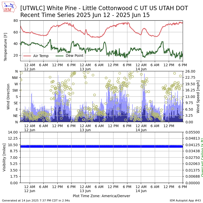
This page creates a simple plot of recent observations from this site.