Past IEM Features tagged: winter2021
The IEM generates per winter storm analyses of snowfall reports over Iowa and tags them by the winter season. Here are the tags used for the previous winter seasons that these maps are available for:
- Winter 2010-2011
- Winter 2011-2012
- Winter 2012-2013
- Winter 2013-2014
- Winter 2014-2015
- Winter 2015-2016
- Winter 2016-2017
- Winter 2017-2018
- Winter 2018-2019
- Winter 2019-2020
- Winter 2020-2021
- Winter 2021-2022
- Winter 2022-2023
- Winter 2023-2024
- Winter 2024-2025
- Winter 2025-2026
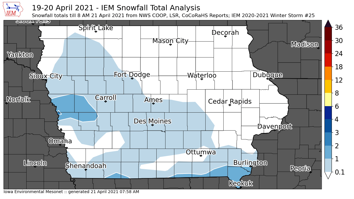
'20-'21 Winter Storm #25
21 Apr 2021 08:03 AMWhile not much of a "winter storm", a very annoying late season snowfall came in two waves on Monday and Tuesday with the heaviest totals of an inch or two confined to west-central and far southern Iowa. The featured map struggles to capture the event as snows that quickly melt before routine daily reporting times cause ambiguity with reported amounts. Creating a snowfall map still seems appropriate and hopefully caps off the snowfall producing winter storms for the season. Some additional light flurries are falling this Wednesday, but should not amount to anything of significance.
Voting:
Good: 9
Bad: 1
Tags: winter2021
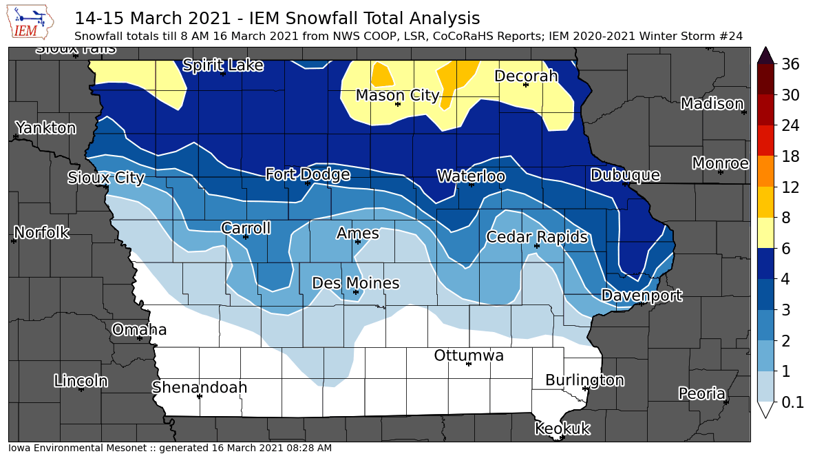
'20-'21 Winter Storm #24
16 Mar 2021 08:33 AMThe warm weather last week brought hopes of being done with the winter season, but the calendar and climatology says otherwise with plenty of time yet this early spring season snow producing winter storms. The featured map presents an analysis of available NWS COOP, LSR and CoCoRaHS reports showing totals over eight inches isolated to far northern Iowa. Any snowfall this time of year will struggle to stick around as ever increasing solar insolation angle and increasing temperatures will work to melt the snow away. The forecast looks to have warmer weather return by the weekend.
Voting:
Good: 8
Bad: 1
Tags: winter2021

'20-'21 Winter Storm #23
22 Feb 2021 08:23 AMJust as we dug ourselves out of a deep and cold temperature hole over the past few weeks, another wallop of a snow producing winter storm slammed the state on Sunday dumping upwards of nine inches of snow over west central Iowa. The featured map presents an analysis of available reports and shows a stripe of six plus inches extending north and east from Omaha to Decorah. If there is any good news, the forecast continues to advertise warmer temperatures this week and hopefully a whole lot of needed snow melting can commence.
Voting:
Good: 12
Bad: 2
Tags: winter2021
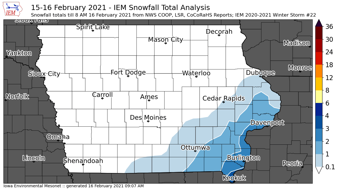
'20-'21 Winter Storm #22
16 Feb 2021 09:14 AMAnd yet another snow producing winter storm system brought upwards of four inches of snowfall over far southeastern Iowa with amounts rapidly decreasing to the northwest of there. This snow again combined with bitter cold temperatures and wind chills making for a miserable time to clear it out of the way. There is some hope in the forecast that warmer weather will arrive next week and that the worst of the cold is now behind us. We still have a number of days to go yet with sub zero low temperatures and high temperatures well below freezing. Just getting above zero is a life goal that many Iowans hope to achieve today. Baby steps.
Voting:
Good: 10
Bad: 1
Tags: winter2021
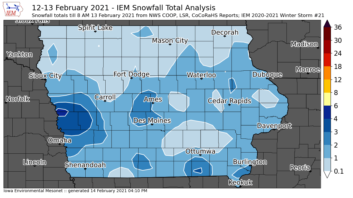
'20-'21 Winter Storm #21
14 Feb 2021 04:15 PMThe winter storm producing snow systems continue to come at a pace faster than can be accounted for here. The featured map is for the snowfall from Friday afternoon into Saturday with totals near five inches reported just east of Omaha. The non-stop snows and bitter cold temperatures have made for a miserable winter weather weekend and looks to continue into the coming week. It appears that maybe temperatures will approach to levels just below freezing by the next weekend, if that is anything to look forward to at this point!
Voting:
Good: 15
Bad: 1
Tags: winter2021

'20-'21 Winter Storm #20
13 Feb 2021 06:55 AMThe snow producing winter storm systems continue to come at a fast pace. The featured map analysis of NWS CoCoRaHS reports is from the snowfall on Thursday into Friday morning with the highest reports of around four inches isolated to the area between Waterloo and Fort Dodge. Besides another accumulating snow storm for Saturday, the big story remains the bitter cold temperatures and wind chills.
Voting:
Good: 10
Bad: 0
Tags: winter2021
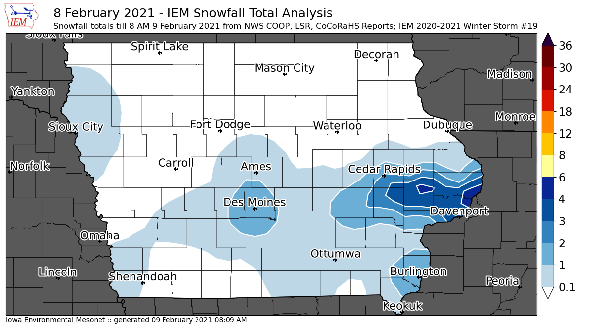
'20-'21 Winter Storm #19
09 Feb 2021 08:14 AMWith a stalled out arctic frontal boundary to our south and ample cold air near the surface over Iowa, every little ripple in the atmosphere continues to produce fluffy snowfall over the state. On Monday, a narrow band setup along Interstate 80 and a bit north to put down up to four inches of very fluffy snowfall with the highest totals reported near Davenport. Perhaps we will get a bit of a break today from the snowfall, but there will be no break in the bitter cold air and wind chill temperatures present. The near term forecast has even colder temperatures in store for the weekend along with numerous chances of snowfall. Full blown winter rolls on unabated at the moment.
Voting:
Good: 8
Bad: 0
Tags: winter2021
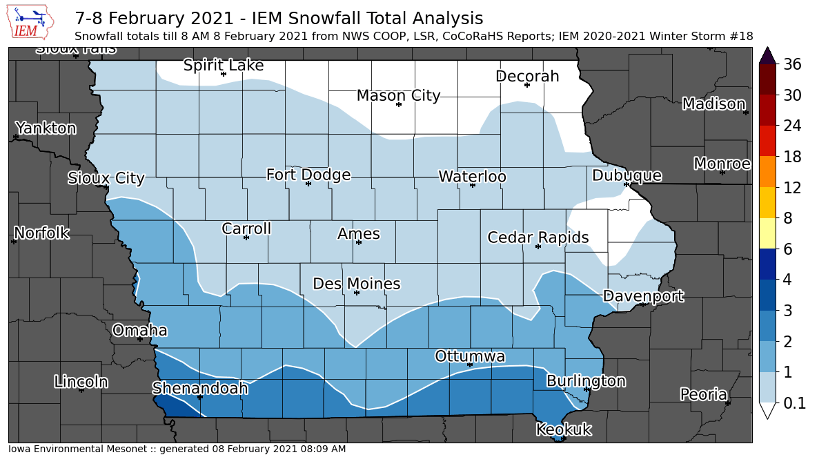
'20-'21 Winter Storm #18
08 Feb 2021 08:13 AMAfter a round of light snowfall on Saturday, another round or two rounds of snowfall arrived on Sunday into Monday. Generating these maps becomes a bit problematic when these snowfalls come so close together as they don't cleanly align with 24 hour snowfall total reports that sometimes span two or more events. Anyway, totals were generally light over much of the state with 2-3 inches isolated to far southern Iowa. Along with the snow, brutal cold temperatures and wind chills were present adding to the misery of nuisance snowfall removal. After much of the winter season being not too bad temperature wise, this week is making up for lost time.
Voting:
Good: 15
Bad: 1
Tags: winter2021

'20-'21 Winter Storm #17
07 Feb 2021 07:59 AMWe are at the point now of having snow producing winter storm systems come faster than the IEM can make daily feature maps of the totals! The featured map presents available snowfall reports from Saturday, but may also include some of the snow falling from the next storm system already over the state this Sunday morning. Totals from Saturday were generally three inches and less over southern Iowa. Bitter cold temperatures and wind chills are present this Sunday morning along with the light snowfall over southwestern Iowa. We will have to await the COOP reports Monday morning to see if today's snowfall will warrant an IEM map analysis too!
Voting:
Good: 13
Bad: 0
Tags: winter2021
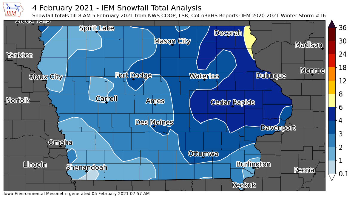
'20-'21 Winter Storm #16
05 Feb 2021 08:02 AMAfter an active winter weather month of January, February has keep the trend going with a significant storm impacting the state on Thursday. Strong winds combined with brief, but intense snowfall rates along with blowing snow to create blizzard conditions during the day. Travel was difficult with a number of major wrecks reported on the interstates and elsewhere. The featured map of available snowfall reports is a bit noisy due to much of the snow falling horizontally and thus difficult to reliably measure. The highest totals were found over eastern Iowa with far northeastern Iowa approaching six inches. The big story going forward are the coldest temperatures so far this season set to arrive for the weekend and stick around for next week and more.
Voting:
Good: 15
Bad: 1
Tags: winter2021

'20-'21 Winter Storm #15
31 Jan 2021 08:08 PMAn active month for winter weather closed out with another storm bringing heavy snowfall to the state. The featured analysis of available NWS and CoCoRaHS reports shows Cedar Rapids within the bullseye for snowfall with over six inches reported in the area. The snow was not the only story with this storm as significant freezing rainfall was also observed over eastern Iowa. The combination of ice and snow making for a big mess to clean up and navigate through. So far this winter season we have avoided significant cold air events with, but the present forecast for next weekend looks to bring the coldest air of the season and have it stick around for a week or more.
Voting:
Good: 16
Bad: 0
Tags: winter2021
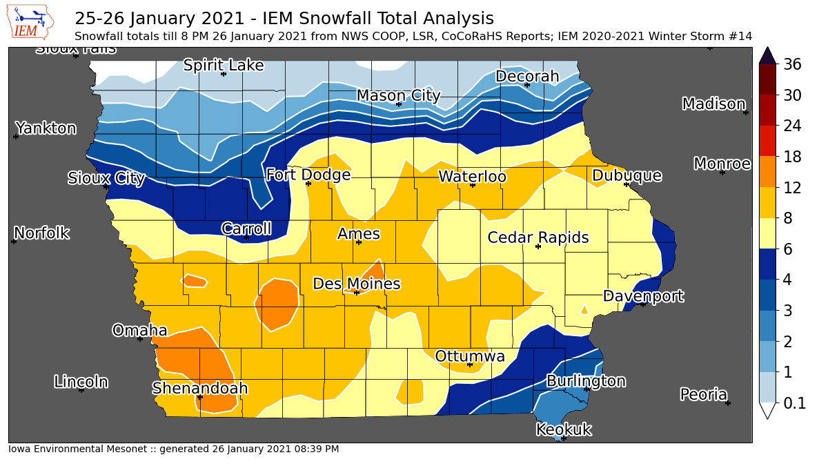
'20-'21 Winter Storm #14
26 Jan 2021 08:29 AMAfter a series of nuisance snow storms, a major winter storm slammed Iowa with some locations over southwestern Iowa receiving more than a foot of snowfall. The featured map is an analysis of available reports from the NWS and CoCoRaHS. Snow is still falling this morning along with blowing snow, so will update the map later today once more reports are received. At least the snow is very fluffy, so shoveling and pushing is not too terrible. The fluffy nature also means it will easily blow around, so road conditions will take some time to improve.
Voting:
Good: 27
Bad: 0
Tags: winter2021

'20-'21 Winter Storm #13
24 Jan 2021 11:34 AMAnother nuisance snow storm brought a few inches of snowfall over the state on Saturday into Sunday. The highest totals were isolated to far northern Iowa and east central Iowa. This event was a prelude to a much more significant event that will impact Iowa on Monday into Tuesday with a Winter Storm Warning already in place over southern Iowa. Event totals around a foot of snowfall are possible with the upcoming storm.
Voting:
Good: 8
Bad: 0
Tags: winter2021

'20-'21 Winter Storm #12
18 Jan 2021 07:26 AMWhile not much for a winter "storm", the snowfall on Saturday into Sunday did meet the arbitrary threshold of a few two inch reports over the state to be included in the IEM accounting. The featured map shows the largest totals confined to southeastern Iowa with a few locations in the Davenport area reporting two plus inches. More light snowfall is over the state this morning and in the forecast for this week.
Voting:
Good: 8
Bad: 0
Tags: winter2021

'20-'21 Winter Storm #11
16 Jan 2021 07:35 AMOur 11th IEM tracked winter storm of the season packed a wallop with blizzard conditions common over western Iowa. The featured map is an attempted analysis of available snowfall reports and shows the highest totals over central Iowa. This snow storm was difficult to measure as the snow came in waves for northeastern Iowa along with some freezing rain and melting temperatures. And as always, when it snows sideways, like in a blizzard, it is difficult to accurately measure. All of that aside, the near term forecast looks quiet again along with seasonable temperatures.
Voting:
Good: 9
Bad: 1
Tags: winter2021
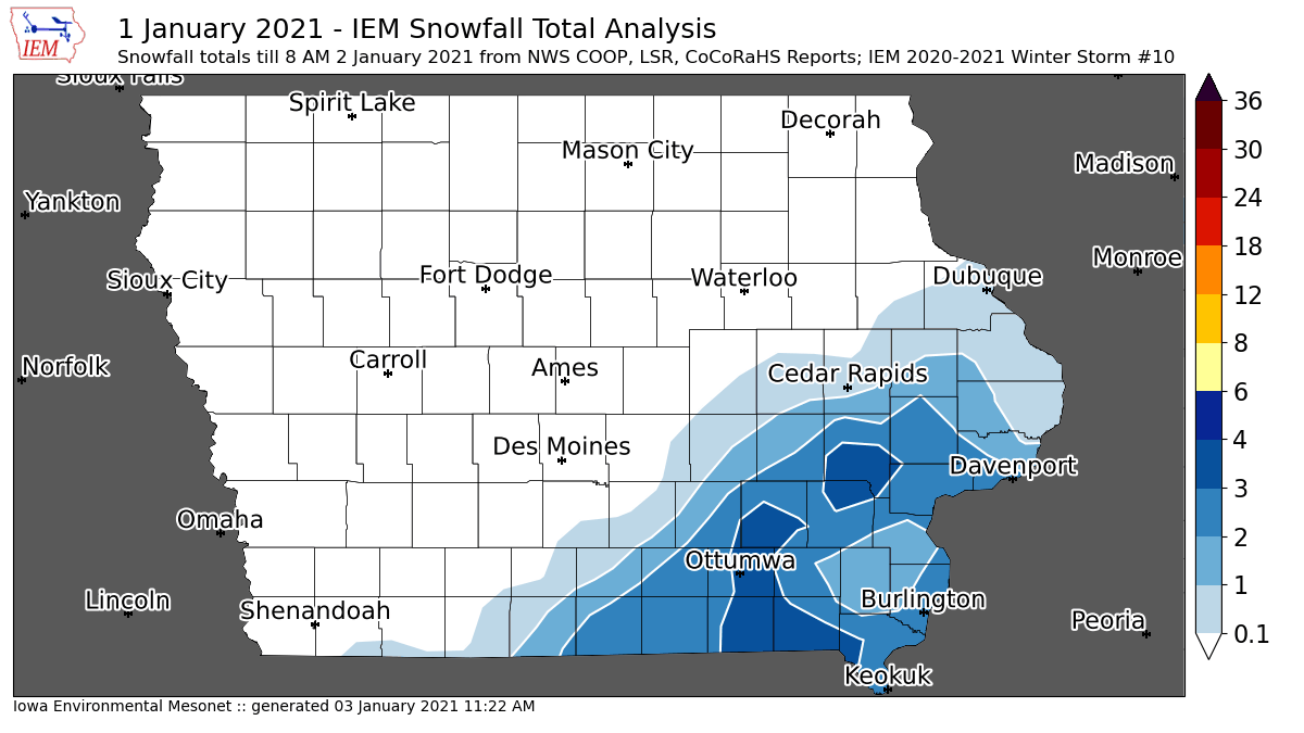
'20-'21 Winter Storm #10
02 Jan 2021 08:44 AMNew Year's Day brought some snowfall and a bit of ice over the southern portion of the state. The featured map shows the highest totals isolated to far south eastern Iowa with amounts generally three inches and less. The near term forecast has things settling down some with no major winter storms on the horizon.
Voting:
Good: 11
Bad: 0
Tags: winter2021

'20-'21 Winter Storm #9
30 Dec 2020 07:15 AMA very significant snow storm for December impacted Iowa on Tuesday with eight plus inches reported over a stripe from southwest to east-central Iowa. The featured map presents an analysis of available reports received so far from the NWS and CoCoRaHS. The map will be updated later today once more reports are received. Snowfall amounts quickly dropped off over southern Iowa as temperatures aloft warmed and precipitation fell as rain, freezing rain, and sleet. In general, this is a rather significant snowfall for December as these types of moisture rich storms are more relegated to the early springtime season. Our next winter storm arrives on New Years as our active winter pattern rolls on.
Voting:
Good: 19
Bad: 2
Abstain: 1
Tags: winter2021
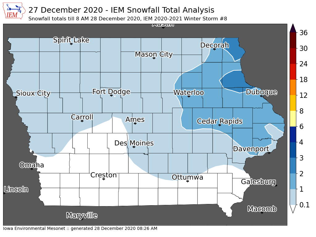
'20-'21 Winter Storm #8
28 Dec 2020 08:26 AMA wintry mix of precipitation fell over Iowa on Sunday with not much snowfall to speak of, but a few reports over two inches over far northeastern Iowa. Freezing rain caused some travel issues for the day, but primary roads are generally in OK condition this Monday morning. Attention now turns to a significant winter storm arriving tomorrow, with much higher amounts of snowfall expected and a Winter Storm Warning already in effect starting Tuesday morning.
Voting:
Good: 8
Bad: 0
Tags: winter2021
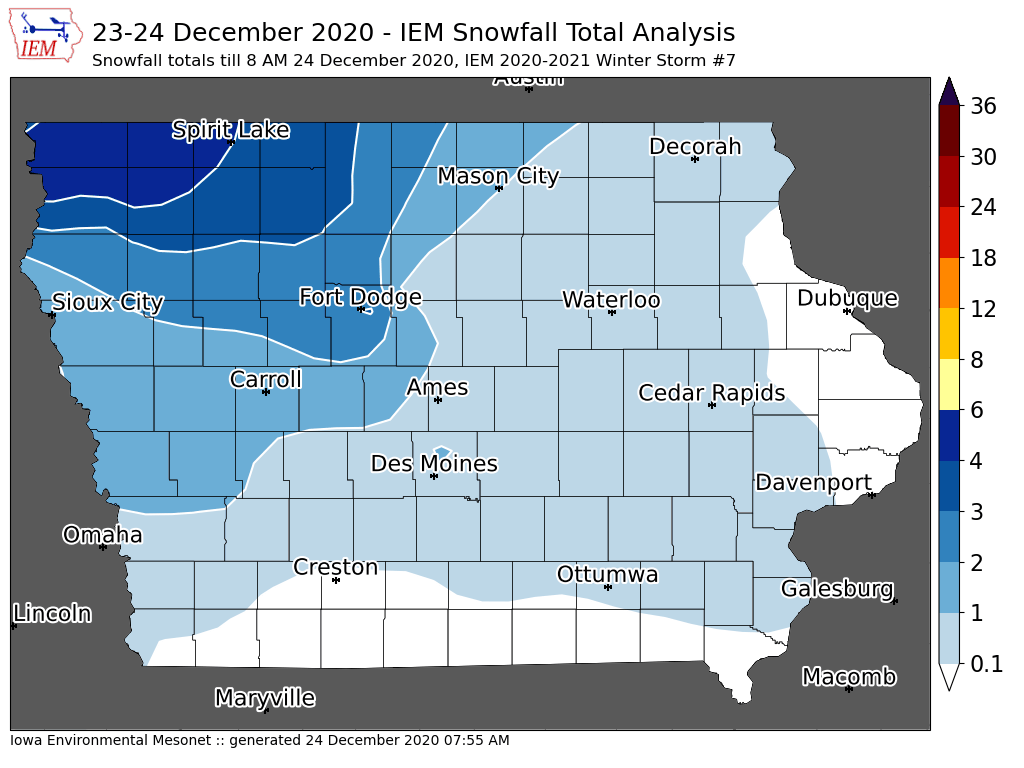
'20-'21 Winter Storm #7
24 Dec 2020 07:59 AMJust in time to make for a White Christmas for some portions of the state, a powerful winter storm brought blizzard conditions over northwestern Iowa on Wednesday along with cold temperatures for the rest of the state. The featured map presents an analysis of available NWS and CoCoRaHS snowfall reports received so far this morning. Totals near four inches can be found over northwestern Iowa. This snow should stick around for a while with not much for above freezing temperatures expected over the next week.
Voting:
Good: 15
Bad: 1
Tags: winter2021
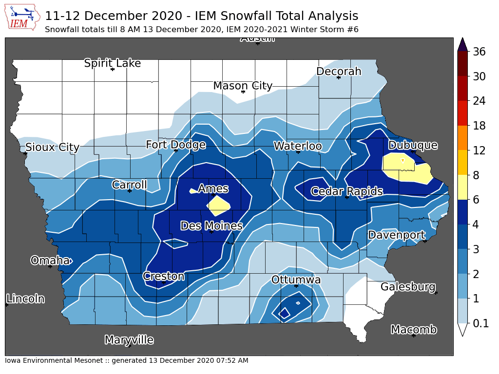
'20-'21 Winter Storm #6
13 Dec 2020 07:57 AMAfter setting record high temperatures late last week, the return to winter over the weekend was abrupt with significant snow falling from Omaha to Dubuque. The featured map presents an analysis of available NWS and CoCoRaHS reports with the highest totals found just near Des Moines and south of Dubuque. Temperatures were not too cold, which made for a liquid rich snowfall, but one that also was able to melt off of cleared roadways on Saturday. This now looks to stick around for most of the week with warmer temperatures expected by the upcoming weekend. Rewording, this snowfall would not appear likely to survive until Christmas.
Voting:
Good: 12
Bad: 2
Tags: winter2021
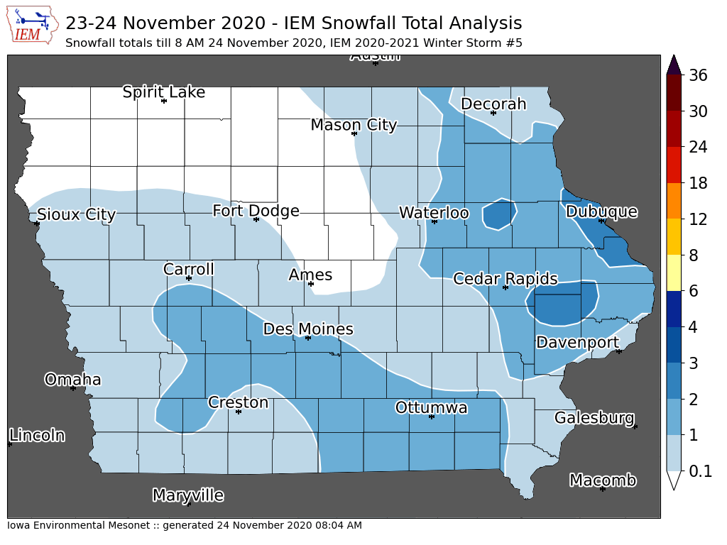
'20-'21 Winter Storm #5
24 Nov 2020 08:09 AMThe featured map presents an IEM analysis of available NWS and CoCoRaHS snowfall reports ending about 8 AM this morning. There is still ongoing precipitation, but temperatures have warmed for most of the state and additional snowfall will be limited. An updated map may be generated if some additional snowfall reports come in from northeastern Iowa. Snowfall totals were generally less than two inches, but was accompanied by some sleet and freezing rain last night making for slick travel conditions.
Voting:
Good: 7
Bad: 1
Tags: winter2021
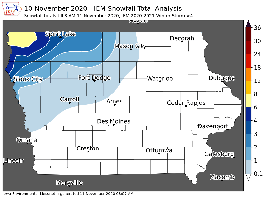
'20-'21 Winter Storm #4
11 Nov 2020 08:10 AMAfter a frantic start to the winter storm season back in October, Iowa enjoyed a nice break with very warm weather to start November. Winter came back with vengeance on Tuesday with snow and freezing rain along with much colder temperatures. The featured map presents snowfall totals from the NWS and CoCoRaHS with values over six inches confined to far northwestern Iowa. Significant accumulations of freezing rain were received just to the east of this snowfall area over north central Iowa.
Voting:
Good: 9
Bad: 0
Tags: winter2021

'20-'21 Winter Storm #3
26 Oct 2020 08:24 AMThe snow producing winter storm systems for only October continued on Sunday into Monday with two waves of snowfall impacting the state. The first wave dumped upwards of five inches over northwestern Iowa with the second wave dumping lighter amounts over central and southern Iowa. The featured snowfall analysis combines available reports from the NWS and CoCoRaHS. Warmer temperatures are in the forecast this week, so the snow will not stick around for long. It has been a wild start to the cold season here in Iowa!
Voting:
Good: 15
Bad: 0
Tags: winter2021
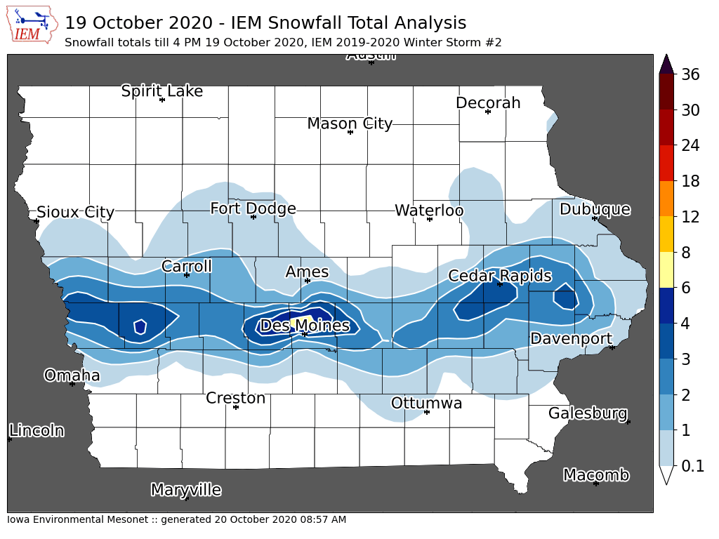
'20-'21 Winter Storm #2
19 Oct 2020 04:21 PMA remarkable very early winter storm brought an intense and very narrow band of heavy snowfall to Iowa on Monday. The featured map is an attempt at showing an analysis of available reports, but the map struggles in some areas with limited reports received thus far. The heaviest totals in the 6 to 9 inch range were found over the northern suburbs of Des Moines with totals rapidly dropping off to the north and south. Even though soil and pavement temperatures were above freezing, intense snowfall rates were able to accumulate on road surfaces resulting in numerous accidents. For October snowfalls, this one is for the record books! Will update the map later once more reports are received.
Voting:
Good: 22
Bad: 0
Tags: winter2021
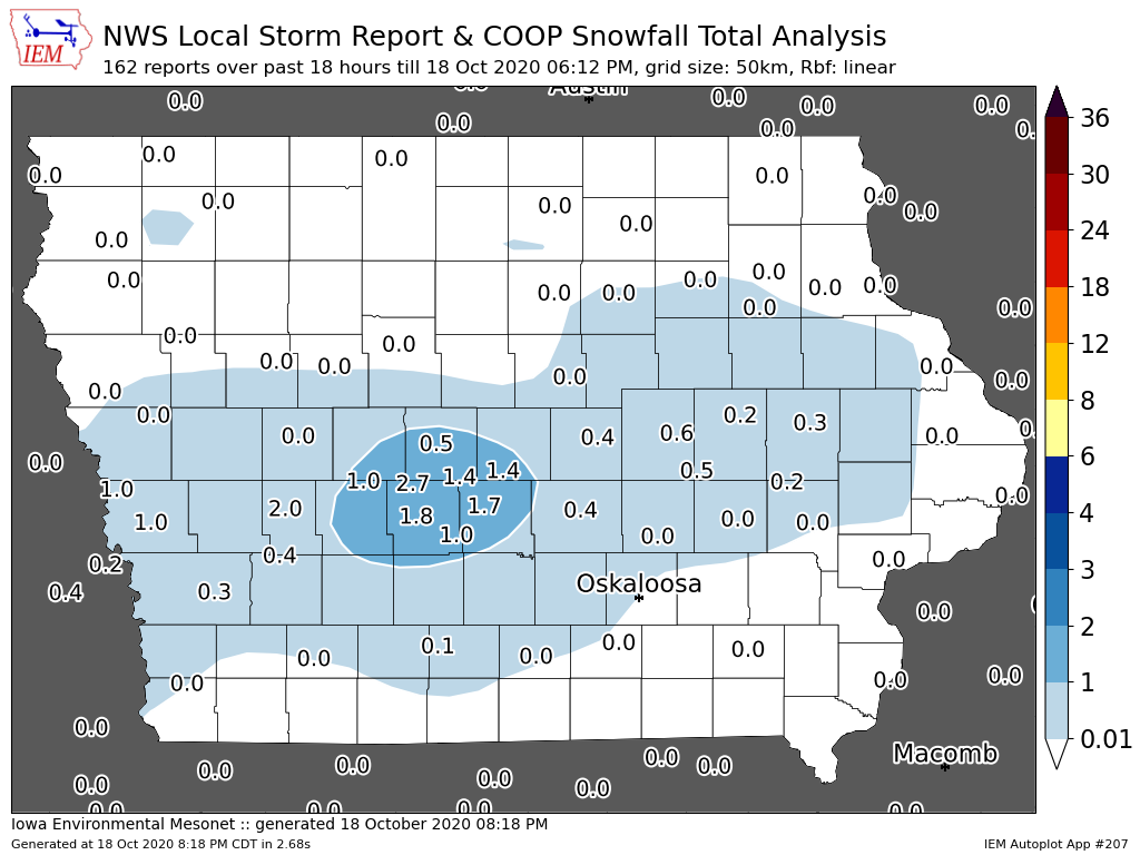
'20-'21 Winter Storm #1
18 Oct 2020 08:36 PMIt is only mid October and we are off running with accumulating snow weather systems! The IEM generates maps like the one presented today for winter storms that produce at least two inches of snowfall and/or have significant impacts / ice. It is an informal accounting based on available NWS and CoCoRaHS snowfall reports. A few reports over two inches were made just west of Des Moines with lighter / trace amounts elsewhere. Needless to say, this is an early snowfall event and the snow had little chance sticking around with warm soil temperatures and brief sunshine this afternoon. Another round of snow is expected overnight into Monday. The craziness of 2020 is being well bolstered by the weather.
Voting:
Good: 13
Bad: 3
Tags: winter2021